Client: Houston Public Works (HPW)
Location: Houston, TX
The project is to conduct a major update of the city’s Hydrologic and Hydraulic model using Innovyze InfoWorks ICM for a better understanding of the main drainage infrastructure as they relate to the capacity of the storm sewers, overland flow routes, and interaction with the Harris County Flood Control District’s regulated channels and bayous. In turn, these models will allow the city stormwater planning to better manage areas with flood risk and identify projects for capital improvement planning.
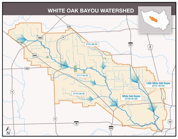
The overall Master Plan is divided into and assigned among multiple consultant teams for separate, major watersheds or watershed groups such as Brays Bayou, Buffalo Bayou, Greens Bayou, Hunting Bayou, Sims Bayou, and White Oak Bayou.
Aurora is working with the HDR Team for modeling support of the White Oak Bayou Watershed. The assigned watershed includes Little White Oak Bayou (E 101-00-00), White Oak Bayou (E 100-00-00), Vogel Creek (E 121-00-00), Cole Creek (E 117-00-00), Brickhouse Gully (E 115-00-00) and other sub-basins outside the city for about 111 square miles of drainage area of which 71 square miles are within the City of Houston. Overall project within the city limits covers about 270 miles of storm sewer (36” and greater), 700 manholes/junctions, 110 miles of studied channels, 50 miles of unstudied channels, and 650 miles of roadside ditches.
Aurora’s scope is to provide data collection support to obtain, review, and confirm related data validity in support of the new model development. Specific data collection tasks include:
• Review of the city’s current GIMS (GeoLink) GIS database as well as available As-builts for related drainage systems and roadside ditches.
• Review data from Harris County, Harris County Flood Control, and TxDOT on prior drainage studies or related drainage systems.
• Data related to green space, parks for detention, or channel improvement.
• Data related to bridges and major culverts across modeled streams.
• Review current LiDAR and overland flow for watershed boundary conditions.
• Support storm sewer network adjustment and identify and adjust data correction and data gap for field survey.
• Support other related model development efforts such as detention evaluation and damage center identification.