Client: North Harris County Regional Water Authority (NHCRWA)
Location: Houston, TX
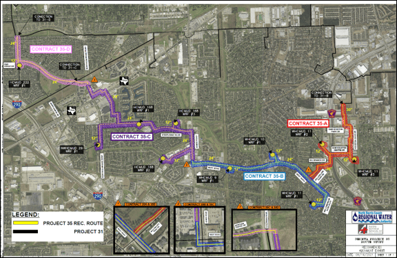
Project 35 is part of the NHCRWA’s ongoing efforts to reduce groundwater usage in the greater northwest Houston area to comply with a mandate issued by the Harris-Galveston Coastal Subsidence District (HGCSD). It represents Phase II of the third loop of the NHCRWA’s 2025 Water Distribution and Transmission System to reduce groundwater to surface water usage within its boundaries.
Consequently, the project consists of approximately 6.5 miles of water transmission lines ranging from 30” to 12” in diameter. The project begins with a connection to an existing 30” WL east of Beltway 8 and terminates the connection to an existing 24” WL west of Fallbrook Dr. Project 35 will connect to NHCRWA Project 31 with Segments 31B, 31C, and 31D. Additionally, Project 35 will connect to 6 MUD districts and 10 water plants in four design packages.
Aurora was tasked to provide a Route Study Evaluation and Alternative Alignment Analysis. Alignment alternatives were conducted along several general corridors including dedicated WL easements adjacent to Harris County (HC) ROW and private properties, Harris County Flood Control District (HCFCD) ROW and easements, CenterPoint Energy (CPN) corridors and easements, and Harris County (HC) road ROW. Subsequently, the route evaluation involved a two-tier approach involving an initial high-level (Tier 1) assessment of all feasible water transmission alignment alternatives and a more detailed (Tier 2) assessment of the more favorable “preferred” alignments. The recommended alignment generally placed water transmission lines along easements along HC ROW, HC road ROW, commercial and residential property, CNP Corridors, HCFCD ROW, and along dedicated easements.